BLAKENEY CHANNEL APPROACHES
(OCTOBER 2020)
MORSTON TO CLEY and BLAKENEY - pilotage notes:
On leaving Morston Creek (speed limit 5 knots), turn sharp right round the Morston Entrance Port and Speed Sign Beacon and follow the Green Starboard Buoys of the ‘Scalp Run’.
These run East, then a sharp turn NE, then a sharp turn East, to Green Buoy - Gordon and Joan Howard.
TO CLEY
Then turn NE following the green buoys towards the Watch House ) arriving at the Red Port Buoy at the start of the ‘ The North Run ‘. Follow the Red Port and Green Buoys to the large sailing club racing buoy with number six on it ( sailing season only ) and the Red Direction Buoy. This is the start of the Cley Channel - see pilotage notes below.
TO BLAKENEY
DO NOT turn to the NE, but continue E - 80 degrees across open water to the Red Port Direction Buoy and follow the Red Port buoys marking the north and Green Starboard Buoys marking the south banks of the wide entrance to the ‘Blakeney Channel’.
These will funnel you to a Red Can Bank Marker and so into the narrow ‘Blakeney Channel‘. Follow the Port and Starboard Buoys to the final Red Port Speed Sign Buoy.
Reduce speed along ‘ The Blakeney Cut ‘ into Blakeney Quay.
BLAKENEY TO CLEY and MORSTON - Pilotage notes:
On leaving Blakeney along ‘ The Blakeney Cut ‘ (speed limit 5 knots ) to the Red Port Speed Sign Buoy and follow the Green and Red buoys of the ‘ The Blakeney Channel ‘. Note - as you are leaving the harbour the green buoys are on the left-hand side and red on the right-hand side.
After the Red Can Bank Marker the channel widens with the green and red buoys only marking the south and north banks.
Continue to the Red Direction Buoy
TO CLEY
and turn sharp right, N, along ‘ The Link ‘ and turn right, past the Red Direction Buoy into ‘ The Cley Channel ‘ - see pilotage notes below).
TO MORSTON
DO NOT turn right but continue W - 260 degrees across open water reaching the Green Buoys of the ‘ Scalp Run ‘. Follow the green buoys to the Morston Entrance Port and Speed Sign Beacon. Turn sharp left round the Beacon, reduce speed along Morston Creek.
A guide to Cley channel - August 2022
The Cley channel is marked with a series of sponsored, named red port hand and green starboard hand buoys along with a series of withys some of which have red or green flags. The channel is checked regularly at low and high tide and buoys/withys moved as required.
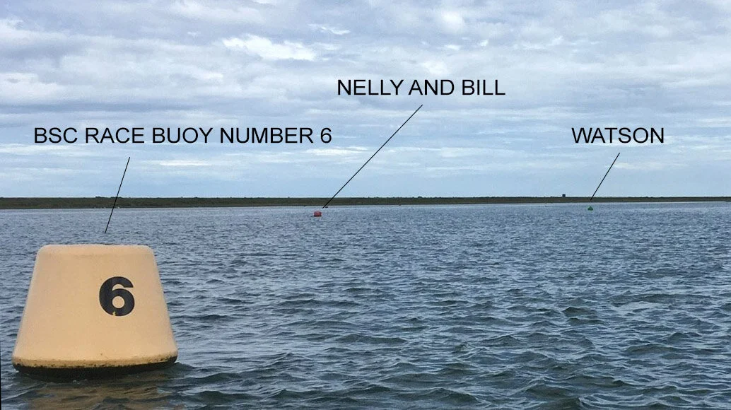
Cley Channel
The start of the channel is in the area of the Watch House near the yellow Blakeney Sailing Club (BSC) racing buoy No 6. The channel is quite wide at the start and is relatively flat marked with port hand buoys, where the water is slightly deeper, and greens on the starboard side marking a ledge. From racing buoy No 6 (note this is only in place during summer months) look out for the red Nelly and Bill and the green Peter Watson buoy to starboard.
Start of the Cley Channel
After Nelly and Bill look for the following reds Five Kendalls, Oscar, Grand Slam and Metcalfe and on the starboard side 4 greens, Watson, Luna S, Chase, Ron and Pam Cripps and Nigel Tamplin the first 3 of which mark the ledge. The channel turns south eastwards towards a series of greens starting with Ella, Savorys, Hills Home Supplies, with a port withy opposite and then Lucy. Next there is a red, Beeston Hall School, and then onto 7 more greens; Tom Archer, Eb and Flow, Gordon Goodwin, MM, Marjorie Threfall, Bob and finally Hippo. There are 2 withys with red flags opposite Marjorie Threfall marking a steep bank on the port side.
Just after Hippo there are two channels. Take the right channel eastwards until you reach a T junction on which there is a withy with red flag which should be left to port. It marks the start of the very obvious small channel which wends its way to Cley, the Windmill is a good guide. Just beyond the large sluice gates you will find the small, welcoming, newly restored Cley harbour which can take boats up to 20 feet.
Start of Cley Channel
The BHA has maintained, preserved and protected the harbour voluntarily for over fifty years.
Buoyage
Everyone who uses Blakeney Harbour will understand how challenging it can be to position and maintain the buoys, beacons and withies around the harbour as channels are shifted by the tides and markers can be moved by the power of nature.
The BHA Buoyage Team and our tireless volunteers conduct regular surveys on the water, on foot and by drone to ensure the navigational aids remain well placed to guide and protect all boat users. Our work is also audited each year by Trinity House. For more information around this, please click here.
However, it remains the responsibility of every skipper to ensure the safety of their craft, crew, passengers and other harbour users. Please help us by reporting any moved, damaged or missing buoys; abandoned boats; or hazards by emailing us.
Below is an interactive map of the buoyage for the harbour and channels. It is essential for your safety that you click 'view larger map' (box top-right of map) and enlarge at least once to ensure the information is accurate. Zoom in on iPad or iPhone if Google Maps App is installed on your device.
It is recommended that the satellite view is turned on to show the positions of channels, banks and raised sand banks. However, please note that although the positions of the buoys etc, are accurate, the Google base map is out of date (current September 2017) and does not show the present situation. Therefore in certain places the position of some buoys can look somewhat strange!
Click on any buoy or beacon for its coordinates and name. Click the box top-left to show the four layers - Harbour Buoys, Cley Channel Buoys, Blakeney Channel Buoys and Beacons, all together or in any combination using the check boxes. Use the + or - buttons bottom-left to zoom in or out of the map.
BLAKENEY HARBOUR BUOYAGE AND LIGHTS
AS AT MARCH 2024
FAIRWAY MARKER
Position:
N 52° 59.230’
E 000° 58.538’
Bearing to no. 1 Starboard channel marker 189º T. Distance to no. 1 Starboard channel marker 0.35nm
NEW Light sequence L Fl.10s
HJORDIS WRECK BEACON
Lighted buoy: Fl(2) 5
Position:
N 52° 59.018’
E 000° 58.144’
HARBOUR ENTRANCE STARBOARD NO. 1
Position:
N 52° 58.907’
E 000° 58.458’
Bearing to fairway marker 9º T. Distance to Fairway Buoy 0.35nm
Light sequence Fl.G(2s)
HARBOUR ENTRANCE STARBOARD NO. 3
Position:
N 52° 58.863’
E 000° 58.262’
Light sequence Fl.R(2.5s)
HARBOUR ENTRANCE STARBOARD NO. 5
Position:
N 52° 58.871’
E 000° 57.978’
Light sequence Fl.G(5s)
HARBOUR ENTRANCE STARBOARD NO. 9
Lighted buoy: Fl.G(2.5s)
Position:
N 52° 58.777’
E 000° 57.530’
HARBOUR ENTRANCE PORT NO. 10
Lighted buoy: QFL.R
Position:
N 52° 58.732’
E 000° 57.552’
CHANNEL MARKER STARBOARD NO. 11
Unlighted buoy: Conical G
Position:
N 52° 58.652’
E 000° 57.352’
CHANNEL MARKER STARBOARD NO.13
Lighted buoy: FLG(5s)
Position:
N 52° 58.513'
E 000° 57.219'
CHANNEL MARKER STARBOARD NO. 15
Unlighted buoy: Conical G
Position:
N 52° 58.373'
E 000° 57.138'
CHANNEL MARKER PORT NO. 16
Lighted buoy: FlR(1s)
Position:
N 52° 58.334'
E 000° 57.239'
CHANNEL MARKER STARBOARD NO. 17
Lighted buoy: FlG(2.5s)
Position:
N 52° 58.187'
E 000° 57.169'
CHANNEL MARKER PORT NO. 20
Lighted buoy: FlR(2.5s)
Position:
N 52° 58.136'
E 000° 57.320'
CHANNEL MARKER STARBOARD NO. 21
Position:
N 52° 58.034’
E 000° 57.376’
Light sequence Fl.G(2)8s
CHANNEL MARKER PORT NO. 22
Lighted buoy: QFl.R(1s)
Position:
N 52° 58.054’
E 000° 57.473’
Light sequence QFl.R(1s)
CHANNEL MARKER STARBOARD NO. 23
Lighted buoy: FlG(4s)
Position:
N 52° 58.090’
E 000° 57.530’
CHANNEL MARKER PORT NO. 24
Lighted buoy: Fl.R(2.5s)
Position:
N 52° 58.125'
E 000° 57.559’
CHANNEL MARKER STARBOARD NO. 25
Lighted buoy: FlG(2.5s)
Position:
N 52° 58.109
E 000° 57.764'
CHANNEL MARKER PORT NO. 26
Lighted buoy: FlR(5s)
Position:
N 52° 58.128'
E 000° 57.748'
CHANNEL MARKER STARBOARD NO. 27
Lighted buoy: FlG(2.5s)
Position:
N 52° 58.136'
E 000° 58.062'
CHANNEL MARKER PORT NO. 28
Lighted buoy: FlR(2)5s
Position:
N 52° 58.150
E 000° 58.029'
CHANNEL MARKER STARBOARD NO. 29
Lighted buoy: QFl.G(1s)
Position:
N 52° 58.145’
E 000° 58.259’
CHANNEL MARKER PORT NO. 30
Lighted buoy: QFl.R(1s)
Position:
N 52° 58.173’
E 000° 58.262’
SOUTH SANDS BEACON STARBOARD NO. 31
Beacon: Fl.G(5s) Position:
N 52° 58.113'
E 000° 58.457'
CHANNEL MARKER PORT NO. 32
Lighted buoy: FlR(2)8s
Position:
N 52° 58.162'
E 000° 58.455'
MORSTON CREEK BEACON PORT NO.34
Lighted beacon: QFl.R(1s)
Position:
N 52° 57.973’
E 000° 59.197’
*The Hjordis Wreck beacon is the only piece of buoyage not maintained and operated by the BHA. A hugely important part of the BHA’s work is buoyage and the BHA works with Trinity House to record, maintain and improve buoyage and safety. The 24 other harbour entrance channel buoys, and the 50 or so inner harbour buoys, beacons and markers are regularly inspected, cleaned and serviced, with new chains and sinkers when necessary, entirely by BHA volunteers.
Recovery Blakeney Fairway buoy for servicing and refurbishment
Lift vessel Hercules recovering Harbour Entrance Buoy no. 2
BHA volunteers lifting and servicing buoys and ground tackle with work vessels Hercules and Titan
Buoyage lighting - Harbour entrance
Fairway buoy - about to be deployed
Sinkers - a tonne apiece
Blakeney Channel marker buoy - Lachlan

Job finished - Harbour entrance buoy
Blakeney Channel marker buoy - Cameron
New BHA port hand lit beacon with speed limit signs at the entrance to Morston Creek
BHA South Sands starboard beacon with light being erected by BHA volunteers. This beacon marks the South Sands and the Southern end of the restricted speed limit line to the Old Lifeboat House on Blakeney Point. This beacon also has the new BHA weather station mounted on it, which can be remotely accessed here.
Completed South Sands beacon with weather station